Friday, 4 April 2014

Post Quake Christchurch

We woke early for our drive to Christchurch and gave Ned a thorough clean before packing up our belongings. We'd agreed to drop Ned off at around 2.00pm and this gave time for a leisurely drive over Gebbies Pass stopping for lunch in the port of Lyttelton.

Lyttelton had suffered significant damage in the 2011 earthquake and this was evident as we drove into the town centre. Many buildings had been demolished. There was however a terrific sense of community and a lively farmers market underway. We enjoyed walking through the produce stalls and community oriented shops. 

One of the community shops in Lyttelton
One stall provided our lunch, a delicious hot pie eaten in the sunshine whilst listening to live music. We also visited a conservation and heritage project: Grubb Cottage. Built by one of the original founders of Lyttleton, John Grubb, this cottage, which dates back to 1851, miraculously survived the earthquakes of 2010 and 2011. It is now run by a trust (http://www.grubbcottage.org.nz/) and I chatted to a volunteer about the conservation work and shared information about Grange Court in Leominster (http://www.grangecourt.org/). If the latter website has had hits from NZ its probably my fault!

Eventually it was time to hand back Ned and check into a motel for our last three nights in New Zealand. This all went smoothly and our motel room was lovely..and seemed enormous after the confines of Ned! We walked around the corner to see the local shops and restaurants and finally settled on an Indian takeaway from the wonderfully named Argee Bhajee. I had a delicious venison curry. 

Next day we walked into Christchurch city centre. Prior to the earthquake of 2011 Christchurch was considered the most English of New Zealand cities with hundreds of historic Victorian Gothic style buildings. It is New Zealand's second largest city. Our walk took us through Hagley Park, across a bridge over the River Avon and into the Botanic Gardens. With imported English oak and sycamore, formal rose gardens and flower beds it had all the hallmarks of an English park. There was little sign of any damage.


The Botanic Gardens

The walk to the centre took about 20 minutes and we were not prepared for the scenes of devastation in the city centre. Its worth recounting what happened. On 4th September 2010 a 7.1 magnitude quake struck 25 miles west of Christchurch on the Canterbury Plains, at 4.35am. It caused significant damage to infrastructure but no-one died or was seriously injured - in part because almost everyone was asleep.


On 22nd February 2011 at 12.51pm another powerful 6.3 earthquake struck Christchurch but this time the results were far more serious. The quake was shallow in depth and the energy released was trapped by the volcanic rock of the nearby Banks peninsula. The epicentre was close to Christchurch itself. This combination of factors magnified the impact and in addition a process known as liquefaction caused the soil below to liquefy and erupt upwards undermining building foundations and covering streets and gardens in a thick mud like substance. It was lunchtime when the quake struck and many people were out shopping and office workers were taking their lunch in a busy city centre. Buildings collapsed and 185 people were killed. In the 12 months that followed there were 1000s of aftershocks including a 5.1 shock in 2012. 

We learnt much of this in an informative and emotionally powerful exhibition called 'Quake City'. It had video footage and interviews with survivors that brought lumps to our throats. Just over three years on the city is still deeply scarred by these events and our walk to the main shopping area brought this home. Its hard to describe accurately and convey the impact but 75%-80% of the buildings in the central business district have been demolished or are awaiting demolition. The most striking casualty is the old Anglican cathedral. 


The old cathedral in ruins
A battle is raging over whether or not to demolish the cathedral. The Anglican church wants to do so but conservationists believe the existing building can be saved and restored. I found myself sympathising with the conservationists in part because the city has so little of its heritage remaining.

Walking around the CBD felt surreal. It was eerily quiet for a large city and felt more like a movie set for some post apocalyptic thriller. Everywhere we went there were empty spaces where buildings had once stood, twisted piles of steel and masonry or half demolished buildings. It was incredibly sad.


The most poignant and achingly sad spot was an art installation standing on the site of a church (now demolished) called 185 Empty Chairs. This is on the opposite corner to the CTV building which collapsed killing 115 people. Subsequent investigations have revealed faults in the construction of this building. Each white chair represents and acts as a memorial for each of the victims who ranged in age from just a few months to the elderly. 


The city is clearly still grieving but amongst the wreckage the rebuild is starting and many temporary measures are underway to aid what will be a long and incredibly costly process of recovery. A pop up style shopping area called the Re:START Mall has opened using brightly coloured old shipping containers and retailers are once again operating - albeit in small numbers. Around the city buildings have been decorated with community art and temporary arts spaces.  

Part of the Re:START Mall
Community art

One or two areas have been restored. An enterprising coffee house has reopened in an old post office building, sharing space with an arts centre, and New Regent Street has some restored Spanish Mission style buildings which are once again trading as shops and businesses.


New Regent Street
Christchurch also has a cathedral again. A Japanese architect has designed and built a temporary cardboard and steel cathedral. This sounds like an unlikely combination of building materials but it is apparently extremely stable and designed to withstand further earthquake shocks.


Views of the Temporary Cathedral


On our second day in Christchurch we visited the absorbing Canterbury Museum and took a ride on a old tram. The tram lines are limited to one stretch at the moment but it saved our legs which had done a lot of walking over the previous few days. In the museum was 'Fred and Myrtles Paua House'. Fred and Myrtle Flutey decorated their home in Bluff with thousands of paua shells that Fred had collected from the beach. This became a bit obsessive but also a tourist attraction and after they had died the house was dismantled and has been erected inside the museum.
Fred and Myrtles Front Room
I advised Mrs B. that she shouldn't get any interior design ideas....

And so we came to our final day in New Zealand. As the forecast wasn't great we caught a shuttle bus to the International Antarctic Centre(IAC). Christchurch is the supply and support bases for the permanent US, UK and New Zealand Antarctic bases. As well as research work there is a visitor centre open to the public. It was great fun. First off we went to see blue penguins being fed. They were all 'rescue' penguins, affected by an illness or injury and incapable of surviving in the wild. 
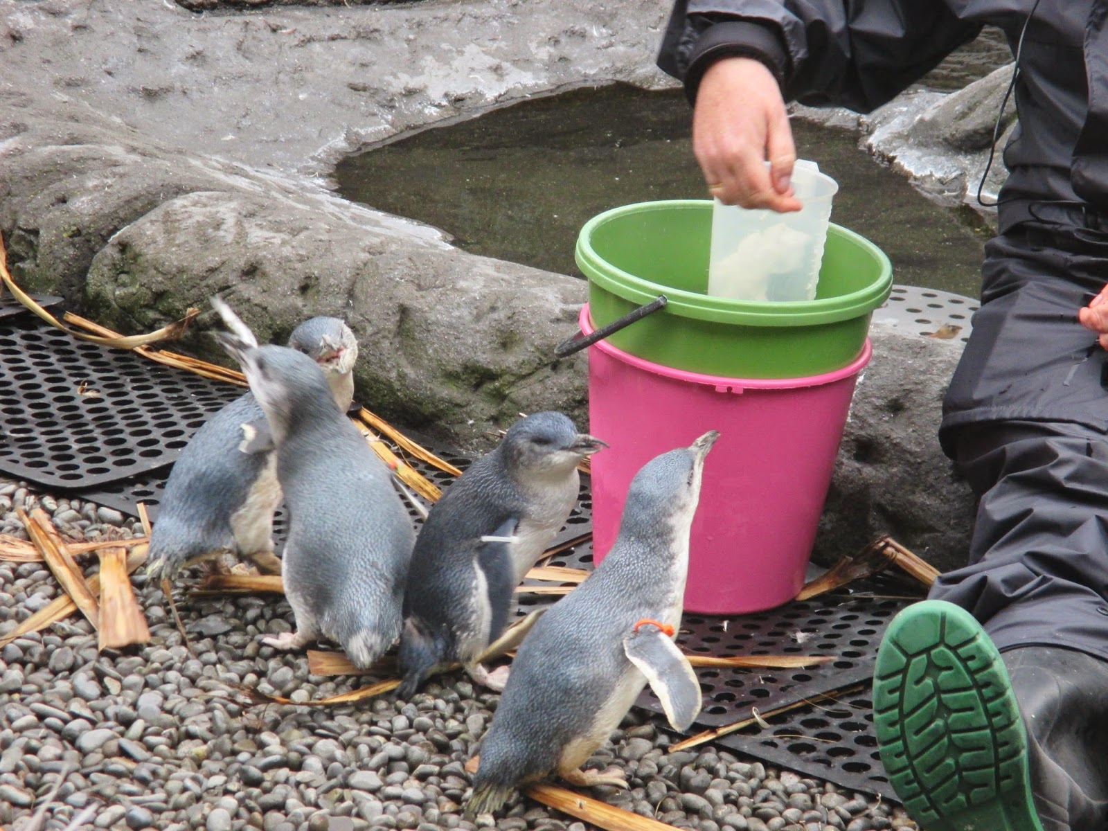
Feeding time
The IAC had provided a safe and secure home with burrows, a large pool and plenty of space and stimulation. Next up was a 4D movie experience. The movie took us on a voyage to the Antarctic and in addition to a 3D film we got moving seats, spray and wind and snow. It was great fun although Mrs B. was shrieking rather a lot when getting sprayed. After my hearing had recovered we went for a ride on the Hagglund vehicle. These are caterpillar tracked vehicles capable of climbing very steep ground, operating on slopes sideways on and they are amphibious...and was demonstrated when we entered 3 meters of water. They are used in the Antarctic to transport people around but are incredibly uncomfortable. After a bumpy ride we returned to the centre to view some of the exhibitions about the early exploration of the Antarctic, the geology, climate and wildlife. The final main attraction was an opportunity to experience an Antarctic blizzard. Donning insulated coats we entered a cold room (-8c) and waited for the blizzard to begin. 

Sadly this was just a static snowmobile

Temperature dropping..
Mrs B. waiting for a blizzard...and doing a penguin impression

Wind machines increased the wind speed to 25mph and the temperature dropped to -18c. It was quite chilly but I suspect not that extreme...I've experienced more cold on the top of Clee Hill in Shropshire. I suppose they don't want to give tourists frostbite!

We whiled away the time watching the blue penguins who all had different personalities and the penguin keeper gave us a behind the scenes look at two female penguins who had fallen for each other and were snuggled up in a burrow. Thankfully gay partnerships seem perfectly acceptable in the penguin world.


Eventually the time came to a) remind Mrs B. we couldn't take a penguin with us and b) leave. We had backpacks to collect and a flight to catch. We checked in our baggage at Christchurch airport and reflected on the wonderful times New Zealand had given us. A land of great contrasts, uncrowded, quirky, harsh and ever changing landscapes, ever present danger from the earth below, unique wild life encounters and some of the most beautiful scenery on the planet. In addition the people were kind and friendly, the food was good and the weather was generally warm and dry (apart from the West Coast). There was one final delight. As the plane took off we were treated to a glorious sunset. It seemed a fitting end to our time in Aetearoa - the land of the long white cloud.


Thursday, 3 April 2014

Bonjour Akaroa!

We had a few days before heading to our final destination in the South Island, Christchurch and we'd chosen to spend it on the Banks Peninsula - about 50 miles from Christchurch. To get there we had to drive over Arthur's Pass on State Highway 73 for the second time. Fortuitously the weather was better than it had been on our first crossing. I once again stopped at the Otira Viaduct and encountered some more keas. They really are fearless and inquisitive birds. As I was trying to frame a photo of the scenery one hopped closer and closer until it was only about a meter away from the camera.

The Otira Viaduct
An inquisitive kea

We stopped in Arthurs Pass village (lunching at the appropriately named 'Wobbly Kea') and took in a few walks. The first climbed to a magnificent waterfall called The Devils Punchbowl'. It was reached by way of a river crossing and stiff climb through verdant rain forest filled with birdsong. We could hear, but not see, bellbirds, native to New Zealand,who have a beautiful melodious range of song. We also saw other birds including silvereye, rifleman and the New Zealand robin which, unlike the British bird of the same name, doesn't have a red breast. One hopped around in front of us for a while and appeared to be very comfortable being close to human company.

New Zealand Robin

The waterfall itself was in full flow as a result of the recent rain. It plummeted into a bowl before cascading over a second drop sending plumes of spray and mist into the air.
The Devils Punchbowl seen from afar through the rain forest
....and up close

To break up the journey we once again camped by Lake Pearson before continuing on the next morning stopping for a coffee in a small town called Springfield. Next to the coffee shop by a play area was an amusing symbol adopted by the town..clearly a modern cultural reference.


Once we'd left the mountains we drove over the flat Canterbury plains, skirting around Christchurch. Our destination was the Banks peninsula and the small harbour town of Akaroa. The Banks Peninsula was formed as a result of volcanic activity about 10 million years ago. Two former volcanic craters are now harbours (Lyttleton and Akaroa) and the landmass between has green mountains and long valleys that run down to peaceful little sandy bays. The geography meant that driving to Akaroa involved taking yet more winding roads...something we'd got quite used to by now. We stopped just before reaching Akaroa to stock up at Barrys Bay Cheese - an award winning cheese maker that has been going for over 100 years. I can testify the award winning Gouda is excellent and the milk is all sourced locally. 

Akaroa is a pretty harbour town, originally a whaling station, but now geared very much towards tourism. Its also unique in New Zealand as having its origins as a French Colony. We walked along the main street which has a good selection of food, clothing and arts and crafts retailers and there was plenty of evidence of its French origins, as many of the road signs are in French. It felt slightly surreal to be wandering down the Rue Jolie.

Akaroa street signs
Akaroa from the water
We explored the town on foot - walking past a lighthouse and up to the monument that commemorated the assertion of British sovereignty..and at this end of town (as if to reinforce the point) some street names were in English, notably a 'Smith Street'.

We'd booked a harbour cruise for the next morning which dawned bright and calm. Perfect weather. At 10.00 am we board a small catamaran with about a dozen other people and were greeted by Patti and Mark who were to guide us around the harbour and out to the Pacific Ocean. We were offered a complimentary drink. Mrs B. opted for some bottled water but when they mentioned an award winning Sauvignon Blanc from a local vineyard my ears pricked up. It was only 10.15 am, which is normally a little early even for me, but I thought it would have been most discourteous not to have tried some local produce.
Supporting the local economy...
The cruise took us around the harbour and Mark pointed out some of the really interesting geology including caves formed not by wind or wave erosion but by volcanic gases. 
Volcanic cliffs, Akaroa


Our hopes of seeing some wildlife were not disappointed too. We passed colonies of shag, fur seals and spotted a little blue penguin.

Little Blue Penguin
Fur seal pup
The highlight though was a sighting of a pod of Hectors dolphins who cavorted through the waves, swam right in front of the boat and put on quite a show. These are the smallest dolphins in the world, growing to no more than 1.4 meters in length and they have a distinctive 'Mickey Mouse ear' shaped dorsal fin. They can only be found in New Zealand.


After returning to shore we decided to explore some more of the peninsula so took Ned up the summit road. This is a high road that provides panoramic views and access to the eastern bays. We detoured down to Le Bons Bay, a remote spot, following the post bus (which also carries tourists). After a picnic lunch we wandered on the beach and to our surprise spotted a solitary yellow eyed penguin. The postman and his group were around and he suggested if we'd got time we try and shepherd it back to the sea. Mrs B. and myself tried to herd the penguin but didn't get very far as after waddling a few meters it resolutely decided to stay put. Eventually we decided to leave it in peace although Mrs B. wanted to smuggle it back to the UK.

A penguin herder...
...and a stubborn penguin
After our failed attempts at penguin herding we climbed Lavericks Peak (775 meters) and this gave stunning views over the peninsula. 


After exploring another remote bay we returned to Akaroa for fish and chips and our last night sleeping in Ned. It was almost time to hand Ned back to the hire company with one last journey to take the following day and then our final few days in New Zealand.


Tuesday, 1 April 2014

The Wild West


Our journey through the South Island had already taken us to the West Coast, but much further North. This time we were approaching from the South. The 150 mile drive along State Highway 6 was spectacular, taking us past Lake Hawea and then Wanaka and over the Haast Pass. The journey took us through an ever changing landscape of high mountains, rain forest, wetlands, lakes, glacier-fed rivers and white water rapids. We stopped for a coffee at Makaroa and then detoured for a walk to the Blue Pools. A track took us over the River Makaroa by way of a swing bridge and through native bush until we arrived at another swing bridge above a gorge opening. Below were bright blue, glacier fed pools of water that were crystal clear. We could see large brown trout in the water and by the river bed people had erected hundreds of tiny cairns. 


The Blue Pools, Makaroa

A few miles further on we stopped again to see a spectacular waterfall and at the Haast Pass we pulled off the road to look at the torrent of white water plunging down rapids in the Haast River. This was to set the pattern for our journey. 

Thunder Creek Falls
The raging white water of the Haast River.


As we drove further west there were fewer and fewer signs of human influence. The rain forest appeared impenetrable and underlined the West Coast's reputation for being an inhospitable environment. This area, along with Fjordland is the wettest part of New Zealand and very few people live here. Although it wasn't raining during our journey dense cloud hung over the forest, mists rose on the mountains above us creating an oppressive atmosphere. Eventually we arrived at Fox Glacier Village and checked into a campsite. The glaciers on the West Coast are very unusual in that they end in temperate rain forest - an environment that can only be seen in parts of South America and New Zealand. I was keen to see Fox Glacier so later that afternoon we made the most of the dry weather and went to see how close we could get to the glacier face. The Department of Conservation closely monitor the glaciers because there are daily ice and rock falls. They are dangerous places and we heeded the warning signs that advised visitors to keep to a marked track. In 2009 two tourists who had strayed from the path were killed by ice fall. A 45 minute walk brought us reasonably close to the glacier face. It was - as most glaciers are - quite grubby! 

The approach to Fox Glacier

Fox Glacier up close. There are guides in the bottom right of the photo to give a sense of scale
The next day heavy rain was forecast but fortunately it started off overcast but dry. We made for Lake Mathieson, famous for its views of Mount Cook and Mount Tasman. The former peak was hidden in cloud but Mount Tasman was just visible although rather strange cloud formations were wrapping themselves around its summit.


We completed a full circuit of Lake Mathieson and our effort was rewarded; although Mount Cook remained hidden from view, we did get the famed reflections of the mountains in the still waters.


Views of Mount Tasman reflected in Lake Mathieson
By the time we reached Franz Joseph to walk to the glacier of the same name the rain had set in. Despite this we walked as far as we could get, got thoroughly soaked but saw the glacier face. 

Mrs B. advising me to go no further...

Two wet walking Bootes...
 Mrs B. suggested we try a trip to the coast as she thought the weather might be better there..and I set off for Gillespie's Beach taking a twisting and turning gravel road for miles and miles until we arrived. It probably wasn't quite what Mrs B. had in mind (golden sand and sunshine)...as we found a windswept, desolate expanse of pebbles. Someone had been creative in the past as we spotted a pebble that had been decorated and left on the beach - which made for a lovely touch.


Gillespies Beach, West Coast, South Island.

Next day the rain had stopped and we continued to head northwards up the west coast. Early morning mist rose like smoke from the swollen rivers and hung above the tops of the forest trees. 

 
Early morning mist rising over the swollen Waiho River

Homes, farms or any sign of human habitation were few and far between until we arrived at a bizarre museum/gift-shop/cafe called 'The Bushmans Centre'. Their signature dish is Possum Pie..and they are currently in dispute with the NZ government as they can't use the possums they hunt and kill themselves to make the pies. Possums are considered a pest in New Zealand, there are 70 million of them so hunting them is actively encouraged...putting them into pies isn't. We settled on a cup of tea and fruit scone...somehow it seemed a safer food choice.


We finally arrived at the small coastal town of Hokitika, the centre of pounami carving. Pounami or greenstone, a form of jade, was and still is much prized by the Maoris and carved or shaped into weapons, ceremonial necklaces and other ornaments. Hokitika was also the setting for the recent Man Booker winning novel 'The Luminaries' set in the gold rush era of the 1860s, and the town retains a fair number of heritage buildings making it possible to imagine what life must have been like 150 years ago. We relaxed here, purchased some pounami necklaces as gifts and walked along a sunny but breezy beach.


Having found a quiet campsite on the edge of town (complete with highland cattle, goats and an alpaca) we watched the sun set into the west on the beach. Once it was fully dark we walked a few hundred meters to see some glowworms in a little dell just across the road from our campsite.

Sunset...
....and glowworms
It was now time to say goodbye to the West Coast for the last time. We were headed back east towards Christchurch and the end of our travels..but still had time to squeeze in a few more adventures before handing back Ned.